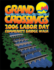
Grand Crossings
 Grand Rapids Mayor George Heartwell came up with a good idea this past summer. Seeing at the high gas prices and looking forward to the annual Labor Day Bridge Walk up at the Mackinac Bridge, Mayor Heartwell decided that Grand Rapids should have a bridge walk of its own on Labor Day.
So that's what about 2,000 people did in Grand Rapids this morning. We followed the Mayor as he walked a little bit more than five miles and crossed seven of Grand Rapids' downtown bridges. Julie and I got there five minutes early, but still there was no sight of the Mayor on the other side of the crowd waiting at the bridge in Ah-Nab-Awen Park (see map at end of this post, #1).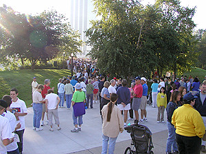 We were to meet a number of other people at the bridge walk, but given the crowd, we were only able to find our friend Pam, who had the sense to call earlier this morning to set up a meeting place. But we soon lost Pam as Julie, Abbey and I had to hang back in the stroller crowd.
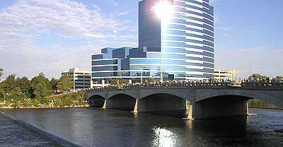 Approaching the bridge, we bumped into Steve and Nora Faber and we walked most of the morning with them. As we crossed over the river and walked north behind the Grand Center (map #2), we could see the thronging crowd crossing over the Michigan Street bridge in front of the building that's become known as "the giant flash cube on the river" (the thruway passes right by this building, and the curved surface ensures that the sun reflects in drivers' eyes every sunny morning).
 As we approached the western side of the Michigan Street bridge (map #3), we could see the bottleneck of walkers passing below us along the river walk. We quickly came to appreciate being in the back of the line with the strollers, dogs and wagons, rather than with the rat race up front.
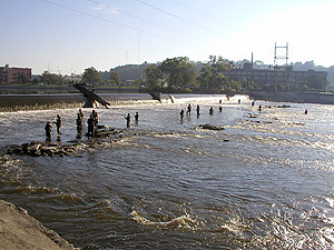 After passing under Michigan Street, we followed the river north along the river walk, passing the fish ladder and dozens of people searching for steelhead in the Grand River (map #4).
As we passed the fish ladder, Julie and I spied two of the three Tom Otterness sculptures we had missed on our previous downtown hike, "Medium Bear" and "Walking Fish."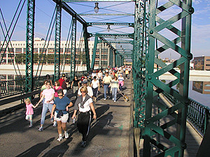 From the fish ladder, we proceeded north to the Sixth Street Bridge (map #5). This is an historic steel truss bridge that used to help the furniture factory workers cross the river between work and home. It was built in 1886 for the whopping sum of $31,000.
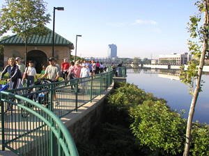 The walk then wound through Canal Street Park, an area I frequently pass through when I walk to downtown (map #6). This park was developed in the late 1990's when some of the furniture and other factories in the neighborhood saw conversion to apartments and condos.
 While we were waiting there for a potty break, along came Alan Adsmond, a friend of ours from the North Country Trail Association. Alan is an AT thru hiker, and his wife Lou wrote a fabulous little book of recipes about the meals she packed in boxes and sent to Alan and his son to keep them nourished on their thru hike.
After meeting Alan, we continued to walk north, around to the east of the historic Water Department building at 1101 Monroe Ave NW. This building always has nice plantings, as they have no shortage of water in the summer.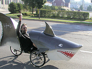 Upon passing the building, we saw a shark headed southbound on Monroe (map #7). "La Grande Fische" is actually a recumbent bike in disguise, and it did a good job of catching the eyes of those walking by.
After crossing the Leonard Street bridge (map #8) at the south end of our neighborhood, the walk turned south and headed back towards downtown on Front Avenue, through a rather uninspired industrial area. We recrossed the Sixth Street bridge, then followed the river walk south to Michigan, walked around the Grand Center to the east, and over the Pearl Street bridge (map #9).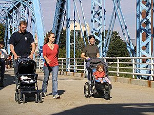 We passed the Grand Rapids Public Museum along the river walk (nice photo of the walkway on the Museum's home page), and then crossed another historic truss bridge (map#10) that connects the area by the GVSU Eberhard Center with downtown west of Monroe Mall. Just north of this bridge is where the new Marriott is being built.
We noticed, for the first time, that there is a little gargoyle-like grim reaper sitting up on the east side of the bridge. I took a photo, but the lighting only returned a silhouette of this critter. He's pretty cool, so we'll get a pic on a future walk.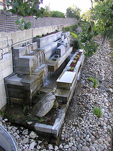 From the bridge, walkers could easily see the newly refurbished
Michael Singer & Sasaki Associates, Inc. work entitled "River's Edge Environmental Sculpture." Built in 1995, this sculpture had been neglected for many years. It has recently been refurbished and overgrowth removed. Lighting for the work has also been installed on the bridge, making it interesting to view at night.
We then crossed the busy Fulton Street bridge (map #11) and bumped into our neighbors Noah and Megan Kruis. This is also where Steve and Nora departed for home.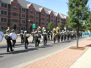 Reaching the far side of the bridge, we were fortunate enough to catch the start of the West Fulton Labor Day parade (map #12). We came up to the corner of Front Street as the drummers set the beat for marching. We walked along with the band for a few paces, then turned north into the beautiful, new GVSU downtown campus.
From there, the hike wound northerly, back behind the Gerald R. Ford Presidential Museum underneath some beautiful red pines. In my opinion, the Ford Museum has some of the best executed public park spaces in Grand Rapids.
When we got to the end, all the completion certificates had been handed out to a crowd that was much larger than expected. But the Mayor's secretary was on hand taking people's names and addresses, so we left Abigail's name so that she could get her certificate in the mail.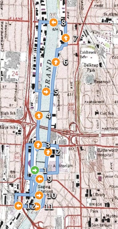


1 comment:
What a GRAND idea and a wonderful thing to do! Great pictures, too.
Mom
Post a Comment